![](/images/other/stat-length.png)
![Tour Mountainbike Les Baroches - rando vtt baroches , bettainviller ,baroche - Photo](https://media.geolcdn.com/t/1900/400/ext.pjpeg?maxdim=2&url=https%3A%2F%2Fstatic1.geolcdn.com%2Fsiteimages%2Fupload%2Ffiles%2F1524743154velo.jpg)
rando vtt baroches , bettainviller ,baroche
adventurer
Benutzer
![Länge](/images/other/stat-length.png)
Länge
25 km
![Maximale Höhe](https://static1.geolcdn.com/siteimages/upload/files/1508320355ic_sort_altitude_max_24dp.png)
Maximale Höhe
286 m
![Positive Höhendifferenz](https://static1.geolcdn.com/siteimages/upload/files/1508320355ic_sort_den_pos_24dp.png)
Positive Höhendifferenz
319 m
![Km-Effort](/images/other/stat-length.png)
Km-Effort
29 km
![Min. Höhe](https://static1.geolcdn.com/siteimages/upload/files/1508320355ic_sort_altitude_min_24dp.png)
Min. Höhe
209 m
![Negative Höhendifferenz](https://static1.geolcdn.com/siteimages/upload/files/1508320355ic_sort_den_neg_24dp.png)
Negative Höhendifferenz
319 m
![Boucle](https://static1.geolcdn.com/siteimages/upload/files/16400158638029165_repeat_loop_refresh_sync_direction_icon.png)
Boucle
Ja
Erstellungsdatum :
2020-06-15 07:39:20.427
Letzte Änderung :
2020-06-15 07:42:29.815
![Mountainbike](https://static1.geolcdn.com/sitytour/trail-icons/202.png)
1h56
Schwierigkeit : Medium
![Scannen Sie diesen QR-Code, um die Tour in der SityTrail-Anwendung zu öffnen](https://capi.geolives.com/qq0zvz2zws4bq2lad0pu/sitytour/trails/2437047/qr.png?size=200)
Kostenlosegpshiking-Anwendung
Über SityTrail
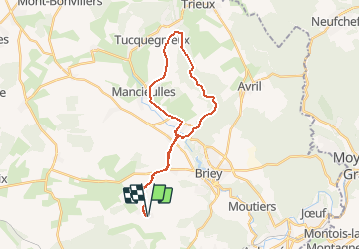
Tour Mountainbike von 25 km verfügbar auf Großer Osten, Mörthe und Mosel, Les Baroches. Diese Tour wird von adventurer vorgeschlagen.
Beschreibung
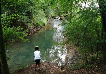
Rando VTT par la voie verte de Mance , passage en foret devant une résurgence , appeler le trou des fées , monter ensuite jusque Bettainviller par les bois , et retour vers les Baroches par la route .
Ort
Land:
France
Region :
Großer Osten
Abteilung/Provinz :
Mörthe und Mosel
Kommune :
Les Baroches
Standort:
Unknown
Gehen Sie:(Dec)
Gehen Sie:(UTM)
710774 ; 5456962 (31U) N.
Kommentare
Touren in der Umgebung
![Tour Zu Fuß Val de Briey - CV Haut Charme - Photo](https://media.geolcdn.com/t/375/260/4e9bdffd-7a79-4a02-9ca5-caf611bbbb83.jpeg&format=jpg&maxdim=2)
![Zu Fuß Zu Fuß](https://static1.geolcdn.com/sitytour/trail-icons/100.png)
CV Haut Charme
Zu Fuß
Einfach
Val de Briey,
Großer Osten,
Mörthe und Mosel,
France
![](/images/other/stat-length.png)
11,1 km | 13,8 km-effort
3h 8min
![](https://static1.geolcdn.com/siteimages/upload/files/16400158638029165_repeat_loop_refresh_sync_direction_icon.png)
Ja
![Tour Wandern Val de Briey - Briey en famille - Photo](https://media.geolcdn.com/t/375/260/7a2bae71-a77e-4de9-b61c-c53dacb17e80.jpg&format=jpg&maxdim=2)
![Wandern Wandern](https://static1.geolcdn.com/sitytour/trail-icons/101.png)
Briey en famille
Wandern
Einfach
Val de Briey,
Großer Osten,
Mörthe und Mosel,
France
![](/images/other/stat-length.png)
8,1 km | 10,3 km-effort
2h 21min
![](https://static1.geolcdn.com/siteimages/upload/files/16400158638029165_repeat_loop_refresh_sync_direction_icon.png)
Ja
![Tour Reiten Val de Briey - Briey 1 - Photo](https://media.geolcdn.com/t/375/260/ext.jpg?maxdim=2&url=https%3A%2F%2Fstatic1.geolcdn.com%2Fsiteimages%2Fupload%2Ffiles%2F1524743154cheval.jpg)
![Reiten Reiten](https://static1.geolcdn.com/sitytour/trail-icons/301.png)
Briey 1
Reiten
Einfach
Val de Briey,
Großer Osten,
Mörthe und Mosel,
France
![](/images/other/stat-length.png)
9,2 km | 10,5 km-effort
1h 53min
![](https://static1.geolcdn.com/siteimages/upload/files/16400158638029165_repeat_loop_refresh_sync_direction_icon.png)
Nein
![Tour Mountainbike Valleroy - vallée de l'Orne - Photo](https://media.geolcdn.com/t/375/260/ext.jpg?maxdim=2&url=https%3A%2F%2Fstatic1.geolcdn.com%2Fsiteimages%2Fupload%2Ffiles%2F1524743154velo.jpg)
![Mountainbike Mountainbike](https://static1.geolcdn.com/sitytour/trail-icons/202.png)
vallée de l'Orne
Mountainbike
Sehr leicht
Valleroy,
Großer Osten,
Mörthe und Mosel,
France
![](/images/other/stat-length.png)
21 km | 23 km-effort
2h 26min
![](https://static1.geolcdn.com/siteimages/upload/files/16400158638029165_repeat_loop_refresh_sync_direction_icon.png)
Nein
![Tour Zu Fuß Val de Briey - Boucle de Mance - Photo](https://media.geolcdn.com/t/375/260/ext.jpg?maxdim=2&url=https%3A%2F%2Fstatic1.geolcdn.com%2Fsiteimages%2Fupload%2Ffiles%2F1545311037marcheuse_200dpi.jpg)
![Zu Fuß Zu Fuß](https://static1.geolcdn.com/sitytour/trail-icons/100.png)
Boucle de Mance
Zu Fuß
Einfach
Val de Briey,
Großer Osten,
Mörthe und Mosel,
France
![](/images/other/stat-length.png)
10 km | 12,2 km-effort
2h 46min
![](https://static1.geolcdn.com/siteimages/upload/files/16400158638029165_repeat_loop_refresh_sync_direction_icon.png)
Ja
![Tour Mountainbike Les Baroches - VTT Baroche hatrize homecourt briey - Photo](https://media.geolcdn.com/t/375/260/ext.jpg?maxdim=2&url=https%3A%2F%2Fstatic1.geolcdn.com%2Fsiteimages%2Fupload%2Ffiles%2F1524743154velo.jpg)
![Mountainbike Mountainbike](https://static1.geolcdn.com/sitytour/trail-icons/202.png)
VTT Baroche hatrize homecourt briey
Mountainbike
Schwierig
Les Baroches,
Großer Osten,
Mörthe und Mosel,
France
![](/images/other/stat-length.png)
44 km | 50 km-effort
3h 18min
![](https://static1.geolcdn.com/siteimages/upload/files/16400158638029165_repeat_loop_refresh_sync_direction_icon.png)
Ja
![Tour Laufen Val de Briey - run matinal - Photo](https://media.geolcdn.com/t/375/260/ext.jpg?maxdim=2&url=https%3A%2F%2Fstatic1.geolcdn.com%2Fsiteimages%2Fupload%2Ffiles%2F1524743154running.jpg)
![Laufen Laufen](https://static1.geolcdn.com/sitytour/trail-icons/103.png)
run matinal
Laufen
Einfach
Val de Briey,
Großer Osten,
Mörthe und Mosel,
France
![](/images/other/stat-length.png)
10,1 km | 13,6 km-effort
55min
![](https://static1.geolcdn.com/siteimages/upload/files/16400158638029165_repeat_loop_refresh_sync_direction_icon.png)
Ja
![Tour Pfad Les Baroches - footing boiser - Photo](https://media.geolcdn.com/t/375/260/ext.jpg?maxdim=2&url=https%3A%2F%2Fstatic1.geolcdn.com%2Fsiteimages%2Fupload%2Ffiles%2F1524743154running.jpg)
![Pfad Pfad](https://static1.geolcdn.com/sitytour/trail-icons/104.png)
footing boiser
Pfad
Medium
Les Baroches,
Großer Osten,
Mörthe und Mosel,
France
![](/images/other/stat-length.png)
11,2 km | 12,9 km-effort
1h 14min
![](https://static1.geolcdn.com/siteimages/upload/files/16400158638029165_repeat_loop_refresh_sync_direction_icon.png)
Ja
![Tour Wandern Les Baroches - rando baroches - Photo](https://media.geolcdn.com/t/375/260/ext.jpg?maxdim=2&url=https%3A%2F%2Fstatic1.geolcdn.com%2Fsiteimages%2Fupload%2Ffiles%2F1553511878bg_sport_marche.png)
![Wandern Wandern](https://static1.geolcdn.com/sitytour/trail-icons/101.png)
rando baroches
Wandern
Einfach
Les Baroches,
Großer Osten,
Mörthe und Mosel,
France
![](/images/other/stat-length.png)
11,2 km | 13,1 km-effort
1h 38min
![](https://static1.geolcdn.com/siteimages/upload/files/16400158638029165_repeat_loop_refresh_sync_direction_icon.png)
Ja